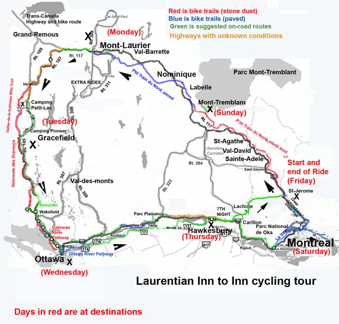
This week-long tour is built around Le P’Tit Train du Nord, a 200 km (120 mile) bicycle path that originates just north of Montreal and continues to Mont Laurier in the Laurentian Mountains (referred to as the Laurentides in French). The loop continues south from there to Ottawa, and then along the Ottawa River before returning to the start location. There is an option to skip Montreal. We have selected the evening stop locations for optimal use of provincial campgrounds and/or inns that are part of the “Bienvenue Cyclistes” network. The total distance for this tour is approximately 600 km (370 miles) with inn and campground options along the way. Check out the bicycle camping version for the option to start at Voyageurs Provincial Park in Ottawa and bypass Montreal. You may follow a reverse version of this tour from Ottawa in this You Tube video made by Alan Metcalf of his fall 2009 tour of the Laurentines.
Resources
- For route maps and cue sheets, we highly recommend purchasing the 8th edition of Cycling Quebec, a guide to Quebec’s 4000 km Route Verte published by Velo Quebec.
- La Route Verte, Montreal
- La Route Verte, Laurentide region
Saturday: Montreal
Inns: Two large inns in Montreal participate in the “Bienvenue cyclists” network:
- Hotel Pomerol 819 boul. de Maisonneuve Est, Montréal, (Québec) H2L 1Y7 (800)361-6896
- Hotel St-Dennis 1254, RUE ST-DENIS, MONTRÉAL. TEL : (800) 291-5927
Both inns charge approximately $15 /night for leaving your automobile in the parking area for the week.
![Montreal_VELO_janv0736x28 [Converted]](https://bikenewengland.com/wp-content/uploads/2016/01/montreal_bike_map.jpg?w=547)
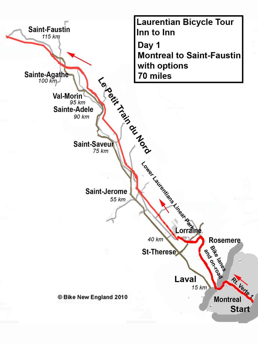
Sunday, Day 1: to Sainte-Adele or Val David
In the morning we depart the hotel, taking la Route Verte 1 paved bike path approximately 12 km through Montreal, crossing to Laval at Pont ile Perry. La Route Verte continues as a stone dust trail next to train tracks through Laval for 17 km. Cross the Riviere des Mille Isles on Route Verte 1 to Lorraine, taking unmarked roads for one km through Rosemere to Sainte Therese, where we join the Lower Laurentians Linear Park (mostly paved). This trail becomes the P’tit Train du Nord Linear Park in Lafontaine just north of Saint Jerome.
Inns:
- Auberge du P’tit Train du Nord, (Bienvenue Cyclistes) 3065, rue Rolland, Sainte-Adèle, Québec. 75 KM from Montreal. 1 877 979-2225.
- Auberge La Bruyere in Saint-Adele. 75 km (47 miles) from Montreal to Sainte-Adele.
- Auberge Champetre, Rt. 117 Sainte-Adele ((800) 363-2466
Campgrounds: Camping Laurentian (Bienvenue Cyclistes) in Val-David. Total. 1949 rue Guertin – Val-David. Tél.: (819) 322-2281. 85 km (53 miles) from Montreal to Val David
Longer distance options: Montreal to Saint-Faustin 119 km ( 74 miles). Montreal to Mont Tremblant 137 km (83 miles)
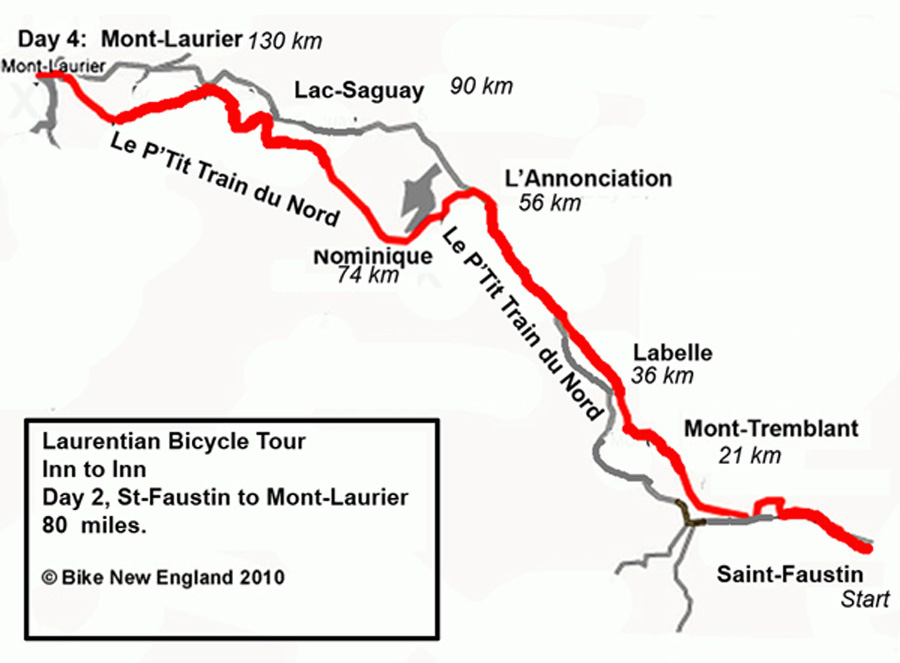
Monday Day 2: Val David to L’Annonciation or Nominique
Our destination today is Lac Nominique. At 50 km from Val David we reach the town of Mont-Tremblant-Village, which is the gateway to popular Parc national du Mont-Tremblant. Full service campgrounds include Camping Diable in the town of Mont-Tremblant_Village or Camping Chutes aux Iroquois in Labelle.) At 60 km in Labelle, Le P’tit Train du Nord becomes a paved trail all the way to Mont Laurier. We continue toward today’s destination, L’annonciation or Nominique.
Inns: Several inns in Nominique:
- Gite le Coup de Coeur, 2088 Chemin des GeaisBleusNominingue
- Accueil du Peti Lac which appears to be a mixed inn/hostel
- Maisons des Jeunes
- L’Auberge le Ville De Nominique,
Camping Options in L’annonciation:
- Camping Le Fou de Roi, adjacent to the P’Tit Train du Nord.
- Camping Municipal Veronique and Camping Le Fou de Roi
Distances:
- Val-David to Nomininque 100 km. 85 km to L’annonciation
- Sainte-Adele to Nominique 110 km. 95 km to L’annonciation
Tuesday, Day 3: Lac Nominique to Mont Laurier
Continue on this fully paved but less populated section of Le P’tit Train du Nord to Mont-Laurier, where you will have time to check out one of the town’s advertised cycling loops, or enjoy a shorter day of cycling to explore this popular destination.
Inns:
- La Maison de la Rive, 415 du Portage, Mont Laurier. (bienvenue cyclists), $70 /night double occupancy
- The Comfort Inn (bienvenue cyclists) (800) 345-6465, 700 Blvd. Paquette, Mont-Laurier, Quebec
Camping options:
- Camping a La Clairiere is 5 miles south of Mont-Laurier on Chemin Du Tour de Lac
- Camping Parc Joan is 2 miles east of Mont Laurier just off Rt. 117.
Distances: L-Annonciation to Mont-Laurier is 45 miles. Lac-Nominique to Mont-Laurier is 34 miles.
Extra ride options: With a shorter ride today, you may choose to add one of their recommended cycling routes or take time to visit this popular town. A 47 km (30 km) ride is up and back down the other side of the North River from Mont-Laurier to Mont-Sainte_Michael. Or ride the 50 km loop south to Notre-Dame_du_Pontman and back.
Longer distance options: You may continue to Maniwaki, 81 miles from L-annonciation, or 71 miles from Nominique.
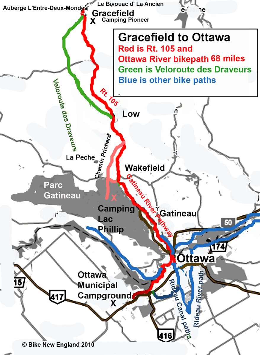
Wednesday, Day 4: Mont Laurier to Gracefield
We leave le P’tit Train du Nord today, taking Rt. 117 west, then Rt. 107 south to Maniwaki, then south on Rt. 95 km to Gracefield. A stone dust/gravel alternative bike route from Maniwakee is the Vallée-de-la-Gatineau Bike Trail which goes along Blue Sea lake, 57 km south to Gracefield.
Inns:
- Auberge L’Entre-Deux-Mondes in Gracefield ($60/ night) (Messines population 1600, Gracefield population 600).
- Hotel Chénierunstarred, 258 ch du Lac Cayamant, Wright (8 km west of Gracefield) (819) 463-2331
- Cabin and camping option: Le Bivouac d’ La Ancien camping Gracefield
Camping options:
- Camping Pioneer, Rt. 105 in Gracefield
- Camping Petit Lac, Messines, QC, 70 km from Mont Laurier.
Distance: 95 km (60 miles) Mont-Laurier to Gracefield. Option from Maniwaki to Ottawa, 80 miles.

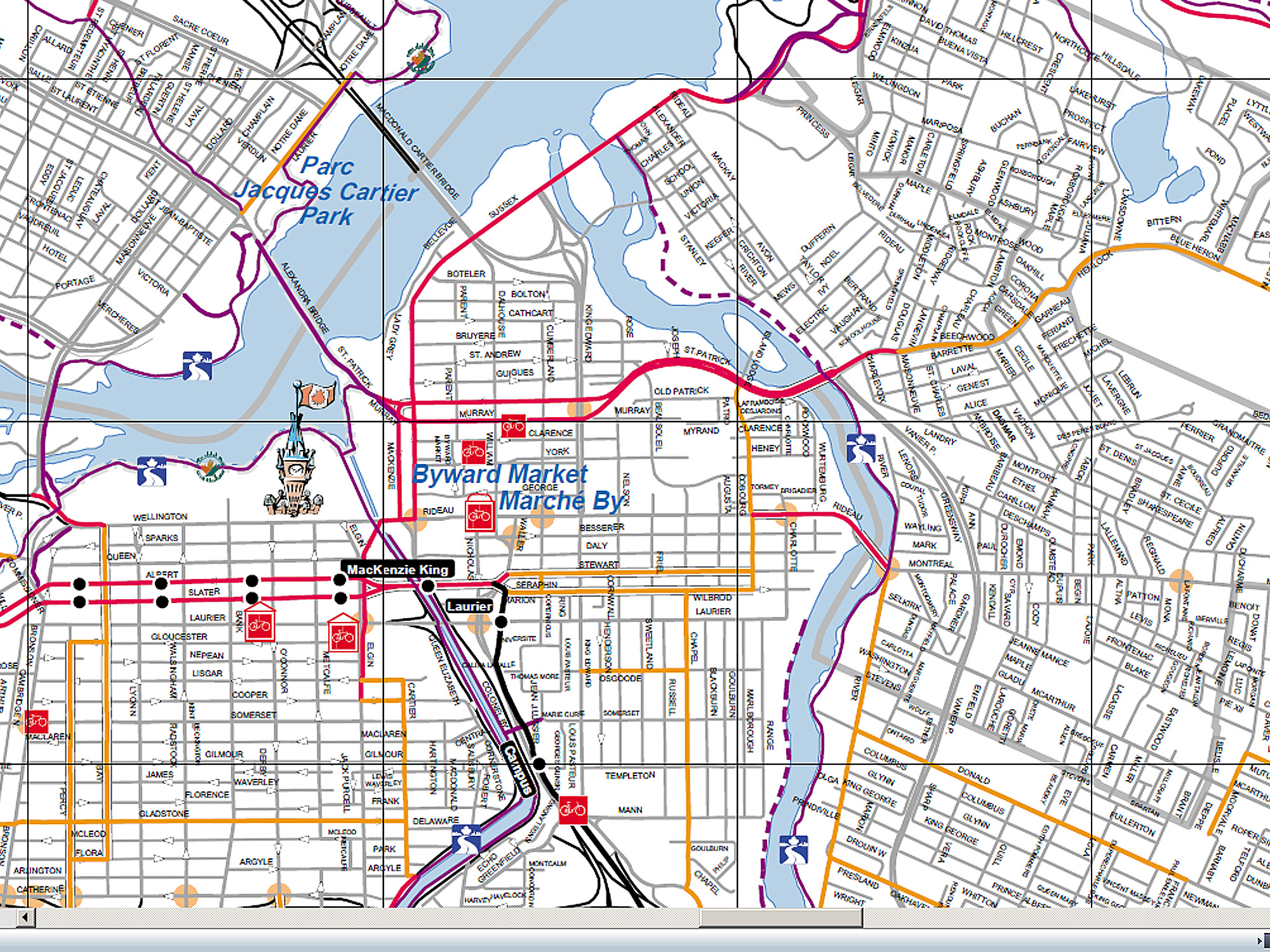
Thursday, Day 5: Gracefield to Ottawa
We ride 64 km south on Rt. 105 from Gracefield to Parc Gatineau north of Ottowa. Instead of Rt. 105, you may also take the gravel Veloroute des draveurs to Low, then continue south on Rt. 105 Rt. 105 has wide paved shoulders but traffic can be heavier near Ottawa. In Wakefield, take the paved bike path and cross the Alexandra Bridge to Ottawa. The bridge has a very wide bike path.
Distance: 100 km Gracefield to Ottawa.
Inns:
- The Byward Blue Inn is in the popular Byward Market area of downtown Ottawa and lists a basic room at an affordable $79 /night: 157 Clarence Street, Ottawa, (3 blocks after bridge).
- Another value is the Gasthaus Switzerland. After crossing the Alexandra bridge, bear right along MacKenzie Drive. In four blocks, turn left on Rideau St., where you will find many inns to choose from. Turn right on Cumberland St. three blocks after turning onto Rideau.
- The Hi-Ottawa Jailhouse Hostel offers private or shared rooms for one of the lowest prices in town.
- There are also several chain inns along or near Rideau St. in downtown Ottawa.
Camping
- The Ottawa Municipal Campground is 20 km (12 miles) west along the Ottawa River Bikeway after crossing the Alexandra bridge. Using this campground will add 12 miles today and the next day.
- Camping in the Parc de la Gatineau north of Ottawa in Quebec. Take Rt. 366 west (not east) from Wakefield instead of continuing to Ottawa. Continue 2 miles to Saint Cecile, then 2 miles south on Chemin du Lac Phillipe to Lac Phillipe family campground. Note that the campground is 74 km (46 miles) from our start in Gracefield, and 47 km (28 miles) from Ottawa. Using this campground would necessitate an additional day of cycling and/or change of routes for the following day.
Cycling in Ottawa: While in Ottawa, don’t miss riding on the Rideau Canal Bikeway, a 16 mile loop on both sides of the canal. Or, ride south on the western side of the canal, which starts just a few blocks from the Alexandra bridge, and then return north into Ottawa on the Rideau River bike path. And check out the Capital Bikeway web page.
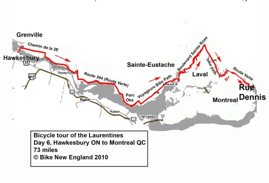
Friday, Day 6: Ottawa to Carillon
Take Rideau St. through Ottawa, cross the bridge over the Rideau River and take the Rideau River bike path to Sussex S
t. In a few blocks you will join the Ottawa River Parkway. Near the end of the parkway, there is an option to take the ferry across the Ottawa River to the Quebec side. We continue in Ottawa, taking local roads near the river to Hawkesbury.
Distances: 130 km (80 miles) from downtown Ottawa to Carillon. The ride may be shortened by 7 miles if using local roads from Ottawa to Hawkesbury instead of staying along the river. The ride is several km longer if taking La Route Verte 1 full distance from Ottawa to Carillon.
Inns: Maison Desormeaux in Carillon welcomes cyclists.
For a shorter ride, stay overnight in Hawkesbury at the Best Western L’Heritage Inn. (110 km from Ottawa). Or you may ride to attractive Van Kleek Hill (a few miles south of Hawkesbury), staying at the Top of the Morning B&B.
Campground option: Voyageur Provincial Park is on the Ottawa River, about half way between Monteral and Ottawa and only a mile from the provincial border. A ferry crosses the river from nearby Pointe Fortune to Carillon.

Saturday Day 7 Carillon to Montreal
We continue east the entire way on La Route Verte 1, (taking Cheminmin 2E to Rt. 344 ) from Carillon to Parc national d’Oka. From there, ride 60 km to St. Jerome, taking La Vagabonde (La Route Verte 1 paved trail) to Deux Montagnes. Continue all the way into Montreal following signs for La Route Verte. Cross the bridge over to Laval. Take Boulevard Ste-Rose east and then a paved bike path along the Boulevard. Continue on Route Verte 1 bike paths back into Montreal to the hotel where we left our cars.
Distance from Carillon: 90 km. (55 miles).
