This is a tentative itinerary for an 8-day cycling trip in the Burren and Connemara areas of the Wild Atlantic Way in Western Ireland. Add a day at the beginning for the flight from Boston to Dublin and train to Galway. Add a couple of days at the end for the train back to Dublin, a day in the city, and a flight back to Boston, for a total of approximately 11-12 days.
Options include eliminating the first two days, and/or eliminating one or both of the last two days.
Road conditions: Many of the routes are on local single-land roads, and were chosen to stay away from traffic. Expect rough pavement and gravel in some locations. There may not be many places to purchase food on some of the routes, if any.
- View the EuroVelo suggested cycling roads at https://en.eurovelo.com/ev1/celtic-coast
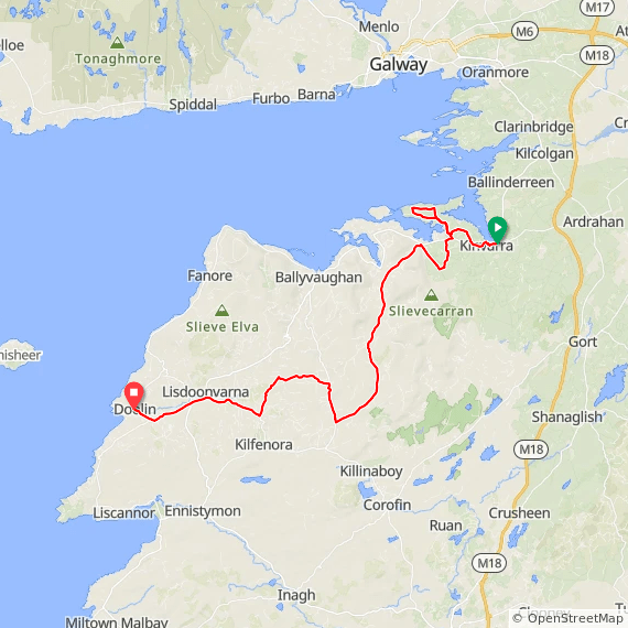
- A rough overview of our whole route: https://ridewithgps.com/routes/45650710
- Ideas for the destinations and routes are from tours featured at Atlantic Coast Cycling, which we plan to hire to support our trip with precise routes, overnight accommodations, luggage transport, and bicycles.
Arrival Day: Fly from Boston to Dublin. Take the train from Dublin Airport to Galway. Stay overnight in Galway
On the RideWithGPS page for each ride, click on More on the upper left side of the page to download a map and cue PDF, print just the cue sheet, and download GPS and other files.

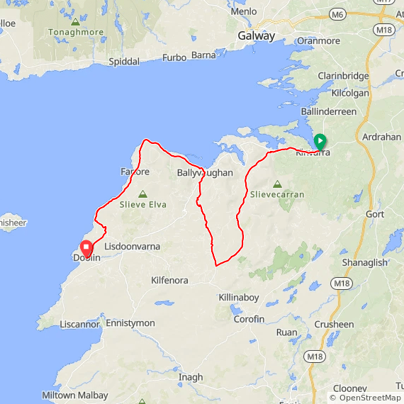
Ride Day 1: Kinvara to Doolin
We meet West Ireland Cycling. They set up bikes, give us routes, provide daily van transport, and take us to the beginning of our first day of cycling at Kinvara. The ride from Kinvara to Doolin is 39 miles with 1900 ft. of elevation. Twenty miles of the relatively flat coastal route is avoided in this version from Kinvara to Ballyvaughnan because it is a busy narrow highway. Kinvara features the 16th Century Dunguaire Castle just east of the village. Doolin has a long scenic cliff walk trail that we can stroll at the end of the day. The population of Doolin is about 500 people.
Route at RideWithGPS. View Day 1 ride at https://ridewithgps.com/routes/45666237
- View Day 1 ride alternative coastal version at https://ridewithgps.com/routes/45654079
- Doolin cycling routes are at https://burren.ie/wp-content/uploads/2015/08/SKMBT_C36017091510511.pdf.
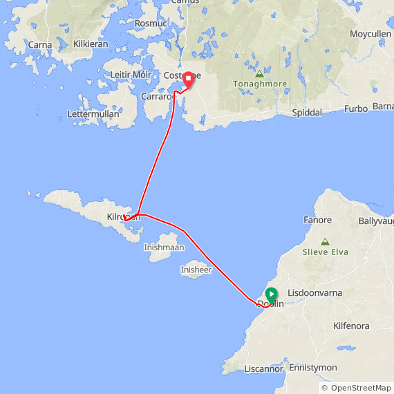
Ride Day 2: Doolin to Liscanoor and Aran Islands
Morning route: 20 miles. This ride has 1450 ft. of elevation, with two long gradual climbs averaging around 4%.
At 3pm: take the ferry to Inishmór, the largest of the Aran Islands, and spend a night there. While at Kilronan visit the ancient fort Dún Aonghasa by bicycle and walking.
Route at RideWithGPS. View the Liscanoor loop at https://ridewithgps.com/routes/45659292
- Aran Islands gallery: https://aranislandsbikehire.com/
- Ferry schedule from Doolin to Liscanoor: 9am, 11am and 3pm
- Ferry schedules are at https://doolinferry.com/aran-islands-ferry-sailing-times/

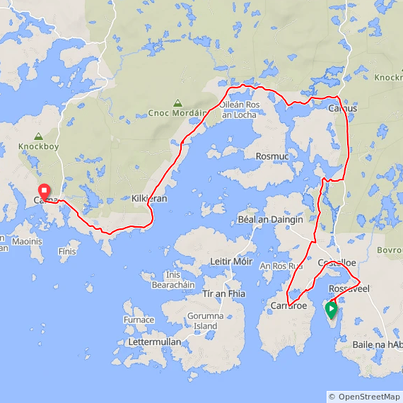
Ride Day 3: Rossaveel to Carna
Take the ferry from Liscanoor to Rossaveel. Ride bikes from Rossaveel to Carna, 34 miles with extra out and back to peninsulas options. The Ferry departs Liscanoor at 10:30 am and 1 pm. The 34-mile ride has 1,130 ft. of elevation with very short steep climbs throughout the ride.
The National University of Ireland, Galway, has an Irish-language and educational center (Áras Shorcha Ní Ghuairim) in Roisín na Mainiach, near Carna. The town is very small, with a hotel, a bed and breakfast, and two eateries.
Route at RideWithGPS. View the Rossaveel to Carna ride at https://ridewithgps.com/routes/45654213
- View the ferry schedule at https://www.aranislandferries.com/time-tables/inismor
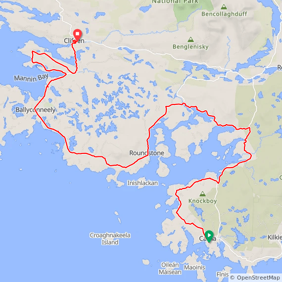
Ride Day 4: Carna to Clifden
41 miles with extra coastal options and a total of 1,600 ft. of elevation spread over the ride. As the largest town in the region, Clifden is often referred to as “the Capital of Connemara” and is frequented by tourists.
Route at RideWithGPS. View the Carna to Clifden ride at https://ridewithgps.com/routes/45654331.
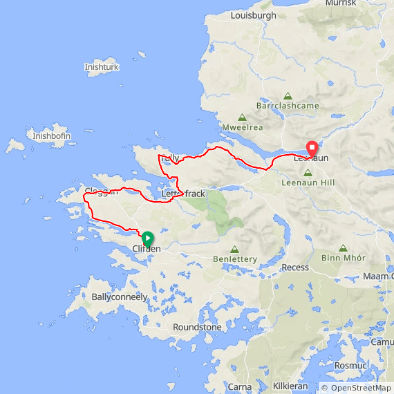
Ride Day 5: Clifden to Leenaun
40 miles, with 1950 ft. of elevation. The largest climbs are in the second half of the ride, up to 7 or 8% for brief sections. Spend the night at Leenaun. Nestled at the head of Ireland’s only fjord, Leenane Village is a picturesque gem with quaint charm and stunning natural surroundings, perched between the majestic Mweelrea and Maamturk mountain ranges.
Route at RideWithGPS. View The Clifden to Leenaun ride at https://ridewithgps.com/routes/45654348.
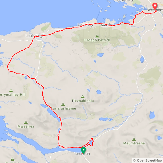
Ride Day 6: Leenaun to Westport
36 miles with 1,380 ft. of elevation, and extra options. The steepest section is in the middle of the ride with a half-mile climb of up to 7%. Westport is designated as a heritage town and is one of only a few planned towns in Ireland. The town center was laid out in the Georgian architectural style and incorporates the Carrow Beg River into the design composition.
Route at RideWithGPS. View the Leenaun to Westport route at https://ridewithgps.com/routes/45659587.
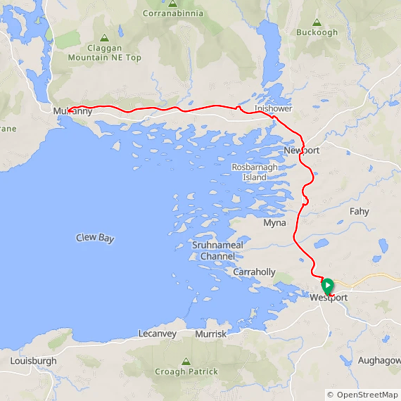
Ride Day 7: Westport to Mulroney out and back
Out and back, 37 miles total with 1650 ft. of elevation, and a long option. Cycle from Westport to Achill and back on the Great Western Greenway, which is mostly paved. Spend our second night in Westport.
Route at RideWithGPS. View the Westport to Mulroney ride at https://ridewithgps.com/routes/45654364.
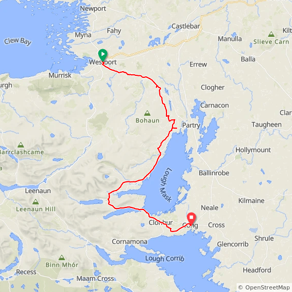
Ride Day 8: Westport to Cong
39 miles with 1820 ft. of elevation spread over the course. The village of Cong with a population of 145 people is widely regarded as one of the most picturesque small villages in Ireland. It has three pubs and 4 lodges. The van will meet us in Cong at the end of the ride and take us back to Galway. Alternatively, we can have the van pick us up in Westport in the morning, and skip this ride.
Route at RideWithGPS. View Westport to Cong ride at https://ridewithgps.com/routes/45654389
Return Days
Take the train back to Dublin. Spend a night or two, and fly home.
