 Assabet River Rail Trail - The Assabet River Rail Trail is a multi-use paved cycling path running through Marlborough, Hudson, Stow, Maynard, and Acton Massachusetts, following the abandoned Marlborough Branch of the Fitchburg Railroad along the Assabet River. 5.6 miles of the section from Marlborough to Maynard have been completed. Eventually the trail will be 12 miles long, extending north… Continue reading Assabet River Rail Trail
  Bruce Freeman Trail - The Bruce Freeman Trail goes through the communities of Lowell, Chelmsford, Westford, Carlisle, Acton, Concord, Sudbury, and Framingham in Massachusetts — following the 25-mile route of the old New Haven Railroad Framingham & Lowell line.. Download a PDF version of the map Download a Trail Brochure PDF
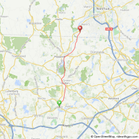 Nashua River Rail Trail - The Nashua River Rail Trail follows the former Hollis branch of the Boston and Maine Corp. railroad for 11 miles through the towns of Ayer, Groton, Pepperell and Dunstable, with a 10-foot wide paved surface for the entire length. The trail travels along a varied and scenic landscape, and no motorized vehicles are allowed. The… Continue reading Nashua River Rail Trail
  South Bay Harbor Trail - The South Bay Harbor Trail is a 3.5 mile-long pedestrian – friendly urban bike trail that will connect Lower Roxbury, the South End, Chinatown, and Fort Point Channel to Boston Harbor at Fan Pier in South Boston. It will also connect these neighborhoods and Boston Harbor to the Emerald Necklace. For centuries Boston Harbor has… Continue reading South Bay Harbor Trail
 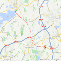 Wachusett Aqueduct trail - The 9 mile Wachusett Aqueduct extends from the Wachusett Reservoir in Clinton Massachusetts to the John J. Carroll Water Treatment Plant at Walnut Hill in Marlborough and passes through Berlin and Northborough. In May 2012 Massachusetts Water Resources Authority announced that “No trespassing” signs along this and four other trails will be removed since they… Continue reading Wachusett Aqueduct trail
  Wenham MA Chebacco Woods mountain biking - Gordon College in Wenham Massachusetts has an excellent trail network for hiking and mountain biking connecting to the other well-maintained trails in adjoining Chebacco Woods. The easy trails wrap around several ponds and are appropriate for beginner and intermediate cyclists, with gently rolling terrain through hemlock and beech forests surrounded by glacial outcroppings. Not shown… Continue reading Wenham MA Chebacco Woods mountain biking
 Trailink.com
- Alewife Linear Park, Cambridge, Somerville
- Alewife Linear Park/Somervillecommunity Path: 2 miles Alewife Linear Park is a beautiful paved trail stretching 2 miles east from the Alewife T-station in Cambridge to Cedar Street in Somerville.
- Amesbury Riverwalk: 1.3 miles linking the fourcommunities of Amesbury, Salisbury, and Newbury
- Ashuwillticook Rail Trail, 11.2 miles. Nestled in the Hoosic River Valley, between Mount Greylock and the Hoosac Mountains in Berkshire County.
- Ashuwillticook Rail Trail, Lanesborough, Cheshire, Adams
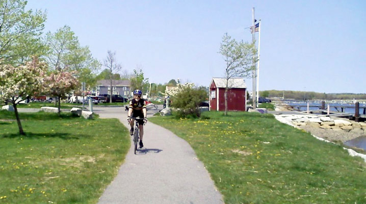
- Assabet River, 5.6 miles, connects the towns of Hudson and Marlborough and parallels the scenic Assabet River.
- Barker Road Trail:0.9 miles. Barker Road Trail begins on the town line between North Andover and Boxford in northern Massachusetts.
- Bedford Narrow Gauge: 3.1 miles The Bedford Narrow-Gauge shares its trailhead at Depot Park in Bedford with the Minuteman Bikeway and Reformatory Branch Trail.
- Blackstone River and Canal Heritage State Park Trail: 3.5 miles. The Blackstone River and Canal Heritage State Park recalls the role of canals.
- Blackstone River Greenway (MA): 2.5 miles will eventually link Worcester, Mass, with Providence.
- Boxford Rail Trail: 2.1 miles in rural Essex County.
- Bradford Rail Trail: 1.3-mile path for pedestrians, cyclists, and joggers.
- Bradley Palmer State Park, Topsfield
- Bridge Street Bike Trail: 1 mile begins near Curtis Park and travels south through downtown Salem.
- Bridle Trail 3 miles. The abandoned rail bed is predominantly owned by the Town of Marshfield. Sections of the abandoned rail bed are open to the public and actively used for recreational purposes such as walking, running, horseback riding, and mountain biking.
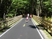
- Bruce Freeman Rail Trail: 6.8 miles. The Bruce Freeman Rail Trail follows the route of the former Framingham and Lowell Railroad.
- Bruce Freeman Rail Trail: Lowell to Framingham
- Callahan State Park, Framingham
- Canalside River Trail: East Deerfield – Turner Falls
- Cape Cod Canal Bike Paths
- Cape Cod Canal Bikeway: 13.5 miles The Cape Cod Canal Bikeway connects Cape Cod Bay and Sagamore on its eastern end with Buzzards Bay and thecommunity of Bourne on its western end.
- Cape Cod National Seashore, Provincetown
- Cape Cod Rail Trail 21.9 miles stretching through quaint villages and along beaches past a diverse landscape of salt marshes, pine forests, and cranberry bogs.
- Cape Cod Rail Trail Dennis-Wellfleet
- Cape Cod Rail Trail, Dennis-Wellfleet
- Center Trail, 0.6 miles from Hopkinton’s downtown to its high school and middle school.
- Charles River Bike Path, Boston, Cambridge, Newton, Watertown
- Charles River Bike Path, Boston, Cambridge
- Chicopee River Canal Rail Trail: 0.21 miles in Chicopee, Massachusetts.
- Chiopee Memorial State Park, Chicopee Falls
- Clipper City Rail Trail & Harborwalk: 1.1 miles near downtown Newburyport.
- Cochituate Rail Trail: 1.1 miles, will run from the Village of Saxonville in Framingham to Natick Center, a distance of 4 miles.
- Columbia Greenway Rail Trail: 2 miles through Westfield in southwestern Massachusetts.
- Connecticut Riverwalk and Bikeway: 5.4 miles. The Connecticut River Walk and Bikeway, which will one day run 21 miles along the river.
- Corridor Park, South End, Roxbury
- Danvers Rail Trail 5.1 miles. The abandoned corridor extends just over 5 miles from Peabody north through the heart of Danvers.
- Dr.Paul Dudley White Bike Path: 13.6 miles, Nestled in Boston’s Charles River Reservation.
- East Boston Greenway: 1.4 miles. The East Boston Greenway is a linear park made possible by the donation of a disused rail corridor by Conrail in 1997.
- Gloria Braunhardt Bike Path: 1.2 miles, parallels the eastern side of the present-day Interstate 95 while following the old interstate roadbed.
- Grand Trunk Trail:4.4 miles. Grand Trunk Trail is part of a larger trail network, the Titanic Rail Trail, which will stretch more than 60 miles through south-central Massachusetts.
- Hanover Branch Rail Trail: 2.6 miles in the southeastern outskirts of Boston.
- Horseneck Beach State Reservation: Westport
- Independence Greenway: 8.1 miles through western Peabody.
- Jay McLaren Memorial Trail: 2 miles on the northern end of Merrimac in the far northeastern corner of Massachusetts.
- Lowell Canal System Trails: 1.9 miles, part of Lowell National Historical Park in Lowell, Massachusetts.
- Lower Neponset River Trail, Dorchester, Milton
- Manhan: 9 miles between Easthampton and Northampton
- Manhan Rail Trail: Easthampton
- Manuel F.Correllus State Forest, Martha’s Vineyard
- Marblehead: 4.1 miles connects Marblehead, Salem, and Swampscott.
- Martin H.Burns Wildlife Management Area Trail: 3.4 miles through the Martin H.Burns Wildlife Management Area near downtown Newburyport.
- Mass Central Rail Trail: 31.9 miles
- Mattapoisett Rail Trail: 1.1 miles between Reservation Road at Mattapoisett Harbor and the Phoenix Bike Trail in Fairhaven.
- Maudslay State Park, Newburyport
- Methuen Rail Trail: 2.4 miles connects threecommunities in northeastern Massachusetts.
- Middlesex Fells Reservation, Stoneham
- Minuteman Bikeway: 9.7 miles through suburban Boston.
- Minuteman Bikeway: Concord to Lexington
- Myles Standish State Forest, Carver
- Mystic River Bike Path, Somerville, Everett Pierre Lallement Bike Path Southwest
- Nashua River Rail Trail, Ayer, Groton, Pepperell, and Dunstable
- Nashua River Rail Trail, NH 12.3 miles through the Massachusettscommunities of Ayer, Groton, Pepperell, and Dunstable.
- Neponset River Greenway: 5.2 miles.
- Nickerson State Park, Brewster
- North Bank Bridge: 0.5 miles The North Bank Bridge, which opened in 2012, provides a safe and convenient pedestrian and bicycle connection between Cambridge’s North Point Park and Paul Revere Park in Charlestown.
- North Central Pathway: 11.4 miles between the cities of Winchendon and Gardner in northern Massachusetts.
- Northampton Bike Path, Northampton-Amherst
- Northern Strand Community Trail, 5.6 miles.
- Norwottuck (Francis P.Ryan Section): 4.9 miles between New South Street in Northampton and the neighborhood north of Look Memorial Park in Florence.
- Norwottuck (Mass Central Section): 10 miles stretching east from Northampton, connects the towns of Northampton, Hadley and Amherst.
- Norwottuck Rail Trail, Northampton
- Old Colony Nature Pathway: 1.6 miles in Provincetown.
- Old Colony Rail Trail:7.9 miles, southeastern Cape Cod.
- Old Eastern Marsh Trail: 1.4 miles between the north bank of the Merrimack River and Mudnock Road in Salisbury.
- Phoenix Bike Trail 3.5 miles.
- Pierre Lallement Bike Path, Southwest Corridor Park
- Pine Tree Brook / Popes Pond Path, 2 miles alongside the brook in Milton, Massachusetts.
- Quarries Footpath: 1 mile.
- Quequechan River Rail Trail 0.68 miles along the northern shore of scenic South Watuppa Pond.
- Redstone Rail Trail: 1.4 miles.
- Reformatory Branch Trail: 4.5 miles through three natural areas.
- Salisbury Beach State Reservation Trail: 0.6 mile
- Salisbury Point Ghost Trail: 1.8 miles.
- Salisbury Rail Trail Connector: 0.3 miles, also known as the Gillis Rail Trail Connector
- Shawme-Crowell State Forest, Sandwich
- Shining Sea Bikeway: 10.7 miles, the only bikeway on Cape Cod to skirt the shore.
- South Spencer Rail Trail: 1.62 miles from downtown Spencer to an area south of town near Spencer State Forest.
- Southern New England Trunkline Trail: 21 miles
- Southwest Corridor Park (Pierre Lallement Bike Path): 3.9 miles
- Southwick Rail Trail: 7.1 miles, continues south as the Farmington Canal Heritage Trail.
- Stony Brook Bike Path West Roxbury, Hyde Park
- Stony Brook Bike Path, Turtle Pond Parkway, West Roxbury, Hyde Park
- Topsfield Linear Common and Wenham: 4.9 miles, Topsfield to Boxfordand Wenham.
- Topsfield Rail Trail: Topsfield
- Upper Charles Trail: 11 miles, connecting thecommunities of Milford, Ashland, Hopkinton, Sherborn, and Holliston
- Wachusett Mountain State Forest, Princeton West Region
- Ware River: 12 miles.
- Watertown Branch Rail Trail: Watertown
- Whitney Spur Rail Trail: 1.6 miles north of the MBTA’s Cohasset Station to the edge of Wompatuck State Park.
- Wompatuck State Park, Hingham
- World War II Veterans Memorial Trail: 1.5 miles on an abandoned corridor once served by the Old Colony Railroad.
