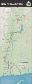
 The 220 mile New England National Scenic Trail in southern New England consists of the Metacomet-Monadnock Trail, Mattabesett Trail and the Metacomet Trail and is better known as the Triple-M Trail. The network starts at Guilford, Connecticut and goes north along the Metacomet Ridge and continues through the Pioneer Valley of Massachusetts to the New Hampshire state line. The Metacomet-Monadnock Trail continues on its own to Mount Monadnock east of Keene NH. The National Park Service was authorized by Congress in 2000 to pursue creation of the combined New England National Scenic Trail, and it was officially designated in 2009.
The MMM Trail system was created over 40 years ago and is maintained by volunteers of the Connecticut Forest & Park Association (CFPA) and the Appalachian Mountain Club (AMC) Berkshire Chapter. About half of the trail is on private land. As part of the designation, the US Secretary of the Interior is instructed to establish a system for ongoing communication with landowners, create a “liability protection fund” to pay legal costs for landowners, and maintain existing landowner uses and rights. No segment of the Trail shall be recognized as such against the wishes of the landowner. A Trail Stewardship Council is being assembled to guide implementation of the Management Blueprint.
More than 100 public roads cross the New England Trail, and there are trailhead parking areas at or near many of these crossings.Detailed Trail Mapsare available from Appalachian Mountain Club and Connecticut Forest & Park Association. For Massachusetts maps, visit theAMC Berkshire Chapter; for Connecticut, visit theCFPA Bookstore. Hiking Metacomet-Monadnock Trail Printer-friendly version. Portions of the combined trails are suitable for mountain biking, but owners have the discretion to limit use.
Descriptions of trail Sections:
- Section 01: MA/CT State Line (Rising Corner) to MA Rt. 57
- Section 02: MA 57 to MA 187/US 20 and the Westfield River
- Section 03: US 20 to Mass Pike I-90 (“Bush Notch”)
- Section 04: Mass Pike I-90 (Bush Notch) to US 202 at Hugh McLean Reservoir
- Section 05: US 202 (Hugh McLean Reservoir) to MA 141 (Easthampton Road)
- Section 06: MA 141 (Easthampton Road) to US 5, the CT River at Mt. Tom Junction
- Section 07: MA 47 (Hockanum) to MA 116, “The Notch” Visitors Center
- Section 08: MA 116, Granby Notch, to Harris Mountain Road via Mount Norwottuck and Long Mountain
- Section 09: Harris Mountain Road via Bay Road to MA 9 at Holland Glen
- Section 10: MA 9, Holland Glen, to Enfield Rd, Mount Lincoln (Partially Discontinuted)
- Section 11: Enfield Road, Mt. Lincoln, Cadwell Memorial Forest to North Valley Road, Pelham via Buffam Falls Conservation Area
- Section 12: North Valley Road, Pelham to Pratt Corner/Cushman Roads, Atkins Reservoir (Partially Discontinuted)
- Section 13: Pratt Corner/Cushman Roads, Atkins Reservoir to Shutesbury Road, Leverett (Partially Discontinuted)
- Section 14: Shutesbury Road, Leverett via Brushy Mountain to North Leverett Road, Village Co-op Store (Partially Discontinued)
- Section 15: North Leverett Road, Village Co-op Store to MA 2 via Ruggles Pond (Wendell S.F.) to Farley Village on the Millers River Valley
- Section 16: MA 2, Erving “Farley” to Gulf Road, Northfield via Hermit Mountain, Erving State Forest and Crag Mountain
- Section 17: Gulf Road, Northfield to MA 78, Warwick
- Section 18: MA 78, Warwick to MA 32, Royalston (Worcester County) via Richards Reservoir and White Hill
- Section 19: MA 32, Royalston to NH 119, Richmond, NH via Falls Brook and Monument Road
- Section 20: NH 119 to NH 12 over Little Monadnock Mountain and Troy, NH
- Section 21: NH 12, Troy, NH over Gap Mountain to NH 124 at the foot of Grand Monadnock
- Section 22: NH 124 to the summit of Grand Monadnock
