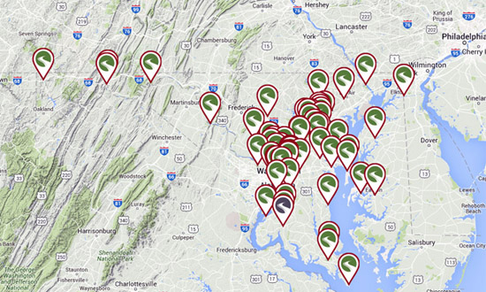
Trails and bicycle paths in Maryland

Anacostia River Trail Length: 2.6 miles, Anacostia Tributary Trail System Length: 29.9 miles; Baltimore and Annapolis Trail Length: 13 miles; Ben Cardin C&D Canal Recreational Trail Length: 1.8 miles; Bethesda Trolley Trail Length: 4 miles; Black Hill Trail State: MD Length: 4.3 miles; BWI Trail Length: 12.5 miles; continue reading...
Rides
 Western Maryland Rail Trail-C&O loop - The paved Western Maryland Rail Trail (WMRT) is located in the Maryland neck between Hancock and Fort Frederick, and runs parallel to the C&O Towpath, by which you can make a pleasant 45-mile off-road loop on mixed terrain. The eastern parking area is located only a few hundred feet south of I-70 exit 12. If this lot is full, continue… Continue reading Western Maryland Rail Trail-C&O loop
  50 rides in southern Maryland - PDF cue sheets provided by the Oxon Hill Bicycle Club calvert-high charles county-cobb island charles county-potomac charles-potomac-60 charlotte hall 68 leonardtown cosca 63 Benedict Metric davidsonville 2 galesville 42 gwynn park 44 merkle meander Indian Head 30 Ironsides Indian Head 67 Nanjemoy laurel springs 45 gilbert run lothian hills mattaponi 24 merkle mattaponi 26 jugbay… Continue reading 50 rides in southern Maryland
 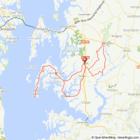 Chesapeake Challenge, Easton MD - The MS Chesapeake Challenge starts at the Talbot County Community Center, north of Easton, Maryland. The century ride is shown below. Take either of the loops for a shorter option. Route at RideWithGPS View and print cue sheet View and print mapLog in to RideWithGPS & click on More to export GPS files
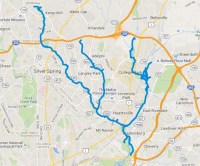 Anacostia Tributary trails, Maryland - Maryland’s Anacostia Tributary Trail System connects several trails managed by the National Park Service: the Anacostia River Trail the Northwest Branch Trail the Northeast Branch Trail the Indian Creek Trail the Paint Branch Trail the Lake Artemesia Trail the Sligo Creek Trail
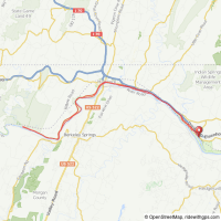
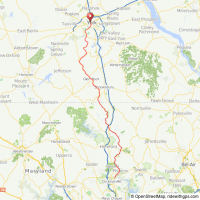 Northern Central Railroad and York County Heritage trail loop - The Northern Central Railroad (NCR), Terry Brown Rail Trail and the York County Heritage (YCH) combine to create a 41 mile mixed terrain ride. Despite its proximity to Baltimore, the trail follows nearly all rural terrain, with much of it along side Gunpowder Falls River). on fine crushed gravel. This map shows the route out and… Continue reading Northern Central Railroad and York County Heritage trail loop
 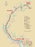 Capitol Crescent Trail - The Capital Crescent Trail (CCT) is a shared use off-road trail from Georgetown in the District of Columbia to Silver Spring, Maryland, built upon the abandoned railbed of the 11 mile Georgetown Branch of the B&O Railroad. The trail is paved from Georgetown to Bethesda, where it becomes packed crushed stone trail to Lyttonsville. Four… Continue reading Capitol Crescent Trail
 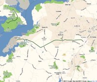 Indian Head Rail Trail - The National Park Service transferred a 13 mile abandoned railroad corridor to Charles County in Maryland’s western shore area, making possible the creation of the Indian Head Rail Trail. The paved trail will provide a pathway between the center of the county to the Potomac River. Parking is at MD Village Green Park at the western… Continue reading Indian Head Rail Trail
 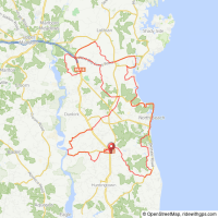 Calvert County Maryland - Calvert County Maryland explores the western shore of Chesapeake Bay. Route options range from 16 to 62 miles. End Hunger In Calvert County is a 501(c)3 non-profit organization 2012 routes are shown below. Start location: Chesapeake Church (map) 6201 Solomons Island Rd., Huntingtown, MD 2063. 63 mile route 49 mile route 35 mile route 16… Continue reading Calvert County Maryland
 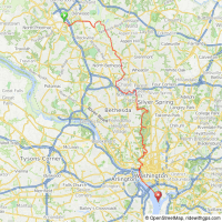 Rock Creek Trail - Maryland’s 14 mile section of the Rock Creek Trail is a multi-use path through southern Montgomery County MD between Rockville and Bethesda/Silver Spring. The northern trail head is at Lake Needwood Regional Park and heads southeast to the DC line where the trail continues on-road following Beach Drive (closed to cars on weekends). The southern… Continue reading Rock Creek Trail
  Potomac Heritage National Scenic Trail - The Potomac Heritage National Scenic Trail is a network of locally-managed trails between the mouth of the Potomac River and the Allegheny Highlands. Through five geographic regions, the varied Trail segments are a means to explore the origins and continuing evolution of the Nation. To date,830 miles of existing and planned trails have been recognized… Continue reading Potomac Heritage National Scenic Trail
  Great Allegheny Passage - The 150-mile Great Allegheny Passage connects with the 184.5-mile C&O Canal Towpath at Cumberland, Maryland, creating a 334.5-mile traffic-free route between Pittsburgh and Washington, DC.The trail has a packed crushed limestone surface on abandoned rail beds, with an average grade of less than 1%. Near the Big Savage Tunnel, the trail crosses the Eastern Continental… Continue reading Great Allegheny Passage