
This tour averages approximately 90 miles per day, starting from Newport Vermont. The ride heads east on the first day to New Hampshire with the option to ride south and back north along the Connecticut river. The second day continues north through New Hampshire wilderness over the border to Lac Megantic in Quebec. The third day turns back east to Magog, one of the most popular towns in the Eastern Townships of Quebec. The Eastern Townships is sometimes called Quebec’s playground, with cycling as a local attraction. The final day starts from Magog with a ride over Mount Orford and several miles on Quebec’s La Route Verte before circling around Mount Sutton to the start point in Newport Vt
This tour is on paved roads, with a few short sections of paved bicycle path in Lac Megantic, Magog, and Waterloo. Where possible, roads with paved shoulders or less traffic have been chosen, avoiding busier highways, but you will be riding with or in traffic. Use caution and ride defensively. The small border crossings on this tour avoid the long lines you experience on the bigger highways. Passports are required.
Download a print description of this tour.
Day 1: 52 mile version
 This shorter version of the Day 1 ride eliminates the 30-mile loop south along the Connecticut River. Cross the river from Bloomfield VT to Stratford NH and rejoin the full ride heading north to Colebrook. This small town offers a few amenities and lodging at a couple of motels.
Cue Sheet
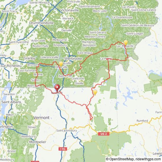
Route Map
GPX Track File
Day 1: Newport VT to Colebrook NH, 85 mile version
 The tour route begins at the Newport City Motel in Newport VT. Newport is a large town in the “Northeast Kingdom” area of Vermont that shares Lake Memphremagog with Magog and the Eastern Townships of Quebec. Many of the highways in northern Vermont offer substantial shoulders for cycling while viewing the magnificent countryside. Our ride heads southeast past Island Pond to the Connecticut River, which separates Vermont and New Hampshire. The longer version of the tour heads south along the river, then turns back North on the New Hampshire side.
View all cycling routes from “Cycling the Kingdom”.
View a cycling route from Island Pond from “Cycling the Kingdom.”
Cue Sheet
Route Map
GPX Track File
Day 2: Colebrook NH to Lac Megantic QC, 88 miles
 Today’s ride climbs gently but steadily through the Connecticut Lakes State Forest, a beautiful wilderness area that extends from Pittsburg to the lonely Canadian border station. After a steep descent to La Prairie in Quebec, the ride turns east through a mix of farmland and hills and then goes north to Lac Megantic. The mapped route ends at the L’Eau Berge Motel near the Parc des Veterans and the town harbor.View the New Hampshire Great North Woods cycling map
View the Eastern Townships cycling map for the Megantic area.
Cue Sheet
Route Map
GPX Track File
Day 3: Lac Megantic QC to Magog QC, 90 miles
 The ride start out on a paved bicycle path along the lake for a couple of miles, then continues through a neighborhood connecting to roads and highways that take you south of Sherbrooke to Magog. La Route Verte 1 crosses the Eastern Townships area west to east, combining regional bike trails known as Grandes Fourches. Most of the section from Magog to Sherbrook is packed stone dust, so this tour instead swings south of Sherbrook on less travelled local highways and roads. You’ll have a few miles of paved Rt. Verte 1as you enter Magog, a very attractive town on the shore of Lac Memphremagog.
- View the Eastern Townships cycling map for the Magog-Sherbrooke-Compton area
- Interactive cycling map for La Route Verte in the Eastern Townships.
- Cue Sheet
- Route Map
- GPX File
Day 4: Magog QC to Newport VT, 88 mile version
 Today’s ride starts out with some moderate steady climbing in Parc National du Mont-Orford. Magog has a nice lakeside park with a bike trail that connects to marked bike routes west of the town and could be an alternative to riding over Mount Orford. This tour bypasses La Route Verte on Mt. Orford which is an unpaved path, but you’ll join an on-road section of La Route Verte 1 before Waterloo. The tour turns south through the most rural and rugged section of the Eastern Townships using the on-road La Route Verte 4 to Sutton. The ride then heads east along the Missisquoi River and crosses the border, ending in Newport Vermont.View the Eastern Townships cycling map for a Magog – Lac Brome loop
View the Eastern Townships cycling map for the Lac Brome-Sutton area
View the Eastern Townships cycling map for the Sutton area.
Cue Sheet
Route Map
GPX Track File
Day 4: Magog QC to Newport VT, 60 mile version
T his option starts out with the climb on Mount Orford, but follows roads just to the west of Lac Memphremagog, then rejoins the long route before re-entering Vermont. There are no paved sections of La Route Verte in this option.View the Eastern Townships cycling map for the Magog-Eastman-Bolton area
Cue Sheet
Route Map
GPX Track File
